Home > News > Industry News

How Does Modern Navigation Technology Ensure Precision and Safety at Sea?

2025-08-08


The open sea, with its vastness and ever-changing conditions, has long been a challenge for mariners. From ancient sailors relying on stars and compasses to today’s sophisticated systems, navigation has evolved into a blend of cutting-edge technology and precise engineering. Modern navigation technology is not just about finding a ship’s location—it is about ensuring accuracy, reliability, and safety in all environments, from busy coastal waters to remote oceanic expanses. As maritime trade, exploration, and travel continue to grow, understanding how these advanced systems work to guide vessels safely is essential for ship operators, crew members, and anyone involved in maritime activities. This guide explores the mechanics of modern navigation technology, its key components, detailed specifications of our industry-leading solutions, and answers to common questions to highlight its vital role in maritime operations.

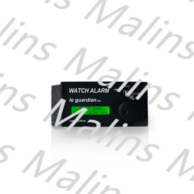
SM ELECTRICS WAR 220.2.0.0 BNWAS

Trending News Headlines: Top Searches on Navigation

Search trends reflect the ongoing focus on navigation as a critical aspect of maritime safety and efficiency, with topics ranging from technological advancements to practical applications:
  • "How GPS and Radar Integration Improves Navigation in Foggy Conditions"
  • "Maritime Navigation Safety: New Regulations for Global Shipping"

These headlines underscore the importance of staying updated with the latest navigation technologies and regulations. For those in the maritime industry, investing in advanced navigation systems and understanding their capabilities is key to ensuring smooth operations and compliance with international standards.


How Modern Navigation Technology Works


Modern navigation systems combine multiple technologies to provide accurate, real-time positioning and guidance. These systems are designed to overcome challenges such as poor visibility, signal interference, and remote locations, ensuring ships can navigate safely in any situation. Here’s how they work:


Our Navigation Equipment Specifications


We specialize in developing high-performance navigation equipment that meets international maritime standards and exceeds the demands of modern maritime operations. Our products are designed for precision, reliability, and ease of use, ensuring ships can navigate safely in any environment. Below are the specifications of our core navigation systems:
Equipment
Marine GPS Navigator (QH-GPS-9000)
Marine Radar System (QH-RADAR-7000)
ECDIS (QH-ECDIS-5000)
Inertial Navigation System (QH-INS-3000)
Technology
Multi-GNSS (GPS, GLONASS, Galileo, BeiDou)
X-band radar with AIS integration
ENC-compatible digital chart system
Fiber optic gyroscopes, MEMS accelerometers
Position Accuracy
<1 meter (with SBAS correction)
Target detection accuracy: ±5 meters
Chart accuracy: ±1 meter (with GNSS input)
Position drift: <0.1% of distance traveled (without GNSS)
Coverage
Global (GNSS satellite coverage)
Up to 72 nautical miles (maximum range)
Global (with ENC updates)
Continuous operation (no external signal required)
Display
10-inch high-brightness touchscreen (sunlight readable)
12-inch color LCD display with 1024×768 resolution
15-inch widescreen display (1920×1080)
Integrated with ECDIS or separate 7-inch display
Features
Waypoint planning, route simulation, speed/distance tracking, weather integration
360° scanning, target tracking (up to 100 targets), collision avoidance alerts, rain clutter suppression
Automatic route deviation alerts, depth contour mapping, tide data integration, chart updates via USB/Wi-Fi
Real-time heading, pitch, roll data; GNSS integration for drift correction; shock and vibration resistant
Power Requirements
12–24V DC, 15W
24V DC, 60W
110–240V AC, 30W
24V DC, 45W
Environmental Ratings
IP67 (waterproof), operating temperature: -20°C to 60°C
IP56 (water-resistant), operating temperature: -15°C to 55°C
IP22 (indoor use), operating temperature: 0°C to 40°C
IP65 (dust and water-resistant), operating temperature: -40°C to 70°C
Compliance
IMO Resolution A.1046(27), IEC 61162-1, SOLAS
IMO Resolution MSC.192(79), IEC 62388, SOLAS
IMO Resolution MSC.232(82), IHO S-57, IEC 61174
IMO Resolution A.694(17), IEC 61131-2
Certification
CE, FCC, CCS
CE, FCC, CCS
CE, IMO, CCS
CE, ISO 9001, CCS
Our Marine GPS Navigator (QH-GPS-9000) offers multi-GNSS compatibility, ensuring reliable positioning even in remote areas by leveraging signals from multiple satellite networks. The Marine Radar System (QH-RADAR-7000) provides long-range detection and collision avoidance capabilities, with advanced features to filter out noise and maintain clarity in harsh weather. The ECDIS (QH-ECDIS-5000) is a user-friendly digital chart system that integrates seamlessly with other navigation tools, providing real-time alerts and route planning functionality. The Inertial Navigation System (QH-INS-3000) serves as a robust backup, ensuring continuous navigation when satellite signals are unavailable.

All our equipment undergoes rigorous testing to withstand the harsh marine environment, including extreme temperatures, saltwater exposure, and vibrations. We also offer regular software updates and technical support to ensure our systems remain up-to-date with the latest regulations and performance standards.


FAQ: Common Questions About Navigation


Q: How often should navigation equipment be calibrated and updated to maintain accuracy?
A: Navigation equipment should be calibrated and updated regularly to ensure optimal accuracy, with schedules varying by device type and manufacturer recommendations. For GPS receivers and GNSS systems, firmware updates should be installed quarterly to improve satellite signal processing and compatibility with new satellite networks. Radar systems require annual calibration by certified technicians to adjust for signal drift, ensuring accurate distance and speed measurements; additionally, radar transducers should be inspected monthly for damage or fouling (e.g., barnacles) that could impair performance. ECDIS must have electronic chart updates installed at least every four weeks to reflect changes in navigational hazards, buoy positions, or water depths—this is mandated by IMO regulations to ensure charts remain current. Inertial Navigation Systems (INS) should undergo gyroscope and accelerometer calibration annually to minimize drift. All calibration and update activities should be documented in the ship’s maintenance logs, as regulatory authorities may inspect these records during port visits.
Q: What backup systems are essential for navigation in case of primary system failure?
A: Having reliable backup systems is critical to ensure navigation continuity in case of primary system failure. For satellite navigation (GPS/GNSS), a secondary GNSS receiver that uses a different satellite network (e.g., BeiDou as a backup to GPS) can provide redundancy, as signal disruptions often affect one network but not others. Inertial Navigation Systems (INS) are essential backups, as they operate independently of satellite signals and can maintain positioning data for several hours during GNSS outages. Paper charts and a magnetic compass remain mandatory backups under SOLAS regulations, providing a failsafe for situations where all electronic systems fail. Additionally, a standalone radar unit (separate from the primary system) can serve as a backup for collision avoidance, while a VHF radio with DSC (Digital Selective Calling) allows crews to request position updates from nearby ships or shore stations. Regular testing of all backup systems—including simulating primary system failures during drills—is crucial to ensure they function correctly when needed.


Modern navigation technology is a cornerstone of safe and efficient maritime operations, combining satellite positioning, radar, digital charts, and inertial systems to guide ships through even the most challenging conditions. By providing precise positioning, collision avoidance capabilities, and real-time alerts, these systems reduce the risk of accidents, ensure compliance with regulations, and enhance operational efficiency. For ship operators, investing in high-quality navigation equipment and maintaining it properly is not just a legal requirement but a vital step in protecting crews, cargo, and the marine environment.
At Malins Marine Service Co., Ltd. we are committed to advancing maritime safety through our range of reliable, high-performance navigation systems. Our products are designed to meet the diverse needs of commercial vessels, from small coastal ships to large ocean liners, ensuring precision and reliability in every voyage. Whether you need a multi-GNSS navigator, advanced radar system, ECDIS, or inertial navigation backup, we have solutions tailored to your requirements.
If you’re looking to upgrade your navigation equipment, ensure compliance with the latest maritime regulations, or need technical support for your existing systems, contact us today. Our team of experts is dedicated to providing the guidance and products that keep your vessels on course and safe at sea.
Previous:No News
Next:No News

Leave Your Message

  • Click Refresh verification code